
July Heat Wave Updates🔥
- JDJweather
- 2 days ago
- 3 min read
Updated: 1 day ago
July 1st Update
The heat wave of 2026 kicks off today with high temperatures in the mid 90s and heat indices around 100F. We experienced some showers and thunderstorms throughout the state early this morning that are currently moving off shore. Skies will continue to clear and temperatures will soar into the 90s with a chance of more showers and thunderstorms this afternoon. Here is the forecast for the next four days.
Forecast
Today: Sunny with a chance of showers and thunderstorms in the afternoon. Highs in the low to mid 90s. Heat index values 100-105F.
Thursday: Sunny. Highs in the upper 90s and low 100s.
Friday: Sunny. Highs in the upper 90s and low 100s.
Saturday: Mostly sunny with a chance of afternoon showers and thunderstorms. Highs in the mid to upper 90s.
Sunday: Partly cloudy with a chance of afternoon showers and thunderstorms. Highs in the lower 90s.
With the confidence of extreme heat increasing the National Weather Service has converted all watches to Extreme Heat Warnings for the entire state. This means for the next several days heat index values will be over 100 degrees and potentially up to 115F.

Previous Post
Extremely hot and potentially record breaking heat is coming to the region over the coming days. High temperatures will approach and exceed triple digits and with the humidity it will feel like 105-115 degrees. It was nearly a year ago to the date we experienced a very similar heat wave with temperatures in the 90s and 100s for several days in late June.
The National Weather Service has issued Extreme Heat Warnings for most of Connecticut for heat indices over 105F. There is less confidence at this time for Litchfield county and Southeast CT but these will likely get converted to warnings as well. The hottest temperatures will be felt away from the shore in SW CT up into the CT River Valley in Hartford County. The Extreme Heat Warning is in effect from Wednesday (July 1st) to Saturday (July 4th).

Forecast
Very hot temperatures in the mid 90s will begin tomorrow on Wednesday to kick off the month of July. This will begin our heat wave which is typically defined as three or more consecutive days above 90F. There is a slight chance of showers and thunderstorms throughout the state during the afternoon and night on Wednesday. Temperatures will soar to near or over 100F on Thursday and Friday. These will be the two hottest days of the heat wave. Factoring in humidity it will feel like 105-115F. Expect mostly sunny skies on these two days with little to no chance of showers and thunderstorms. On Saturday, Independence Day, temps will slide back a bit into the mid to upper 90s.The heat will slowly break down on Sunday with highs in the lower 90s and upper 80s for Monday. Even though the Extreme Heat Warning only extends through Saturday, Sunday will continue to be a very hot day and continue the heat wave. Unlike a lot of extended periods of extreme heat we've seen, this heat wave will not feature a clean break from the hot weather, rather slowly decreasing temperatures through early next week.
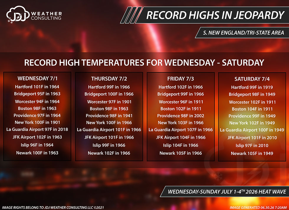
Records
Record high temperatures for the Tri-State Area and Southern New England are possible over the next four days. Some records may be possible on Wednesday but the best chance of breaking a lot of these will occur on Thursday and Friday. With temperatures falling back into the mid to upper 90s on Saturday it will again be a bit harder to break these records. Here is an overview for all the records across the region for July 1st to July 4th.
-JDJ


Comments