
January 25-26th Snowstorm Retrospective & Verification
- JDJweather
- Feb 2
- 3 min read
The January 25-26th Snowstorm was one for the record books. This storm broke several daily snowfall records across official climate sites as well as made the top 10 list for all-time snowstorms, including Boston. Not only was this a very large storm in terms of snowfall but it was extremely cold as well. Most of the Northeast saw temperatures in the single digits and low teens during the height of the storm Sunday afternoon. After all was said and done, a large area of 12"+ blanked much of Southern New England with lesser amounts across the Tri-State Area. Let's take a look at what happened and how we did with the forecast.
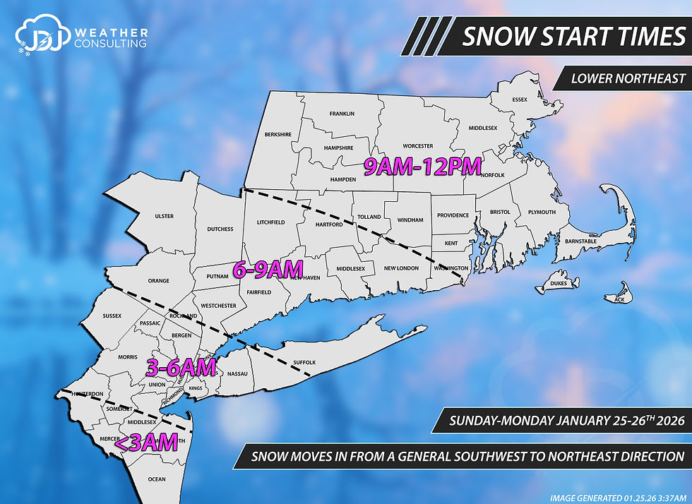
Timing:
As we approached Sunday models continued to push the start time up for the Tri-State Area and Southern New England. We adjusted our forecast accordingly and bumped up the start time a couple hours for the entire area. For the most part this was very close, as far Southwestern Connecticut started to see snow fall just after 5AM. The snow quickly spread E/NE and by 8AM it was snowing across most of the state. In general, snow start times were close to what we predicted, albeit on the earlier side.
Snowfall Rates:
The heaviest snow was expected to fall at rate of 1-3" per hour. This verified completely for the entire region including Connecticut. After snow began it quickly picked up at a rate of over 1" per hour almost everywhere. This continued and increased throughout the morning. The heaviest snow occurred from late morning through late evening and began to wind down shortly before midnight. Light snow continued on and off after midnight and through Monday. An area of heavy snow developed for Massachusetts Monday night which also came down at a very heavy rate.

Precipitation Types:
This storm was forecast to be a majority snow event for much of the state of Connecticut with sleet mixing in towards the end of the main part of the storm. Sleet did in fact mix in for the southern 1/3rd of the state but most towns we able to fight off a complete change over. Heavy snow & sleet mixture persisted from early evening to just before midnight. Areas closer to the shore saw more sleet and eventually a complete changeover. This didn't occur until the bulk of the snow was about over.

Winds:
Compared to a typical nor'easter winds were not the main story here and blizzard conditions were never met. The wind forecast verified with peak gusts in the 20-40mph range for much of the state. Winds started off light through the morning and early afternoon in the 5-15mph range and increased throughout the day. By evening winds had already begun gusting to over 20mph, especially along the shoreline. This caused some blowing and drifting of snow during the night.

Snowfall Amounts:
The most important and crucial part of the forecast that everyone wants to know is "how much"? Our final forecast for the state of Connecticut was 12-18" for 90% of the state and 8-12" along the shore and Southeastern Connecticut. Much of the state verified in these ranges but mainly on the higher end for most. Parts of northern Connecticut eclipsed 18" with amounts up to 21" reported. Along the shoreline most towns ended up in the 10-12" range with some higher amounts. As mentioned earlier, sleet held down accumulations but not as much as we were anticipating. In retrospective the best call for the state would have been 10-14" for the southern 1/4 of the state with 14-20"+ everywhere else.
Across the Tri-State Area and Southern New England we saw a similar story play out with snowfall amounts mainly verifying albeit on the upper end of the ranges. For Massachusetts we ended up being too low, especially in E/NE part where a heavy band of snow on Monday allowed for totals to eclipse 18" across a good chunk of the state.
Here are the snowfall totals for Southern New England/Tri-State Area and Connecticut. Keep in mind the color shaded ranges was slightly tweaked for the snowfall analysis map to 10-14/14-20/20-27". This was done to be more in line with what the storm produced across the area. You can look at exact reports for towns in Connecticut to see the actual final numbers.


If you would like to see more images for this event you can check it out in our archive below. To see all the storms for this winter so far, see our Winter 25-26 page.
-JDJ


Comments