
Surprise Sunday Snowstorm.
- JDJweather
- Jan 17
- 2 min read
Updated: Jan 18
Sunday 8AM Update:
Snow is underway for much of the state right now and will continue light to moderate through the morning and early afternoon. Temperatures are cold right now in the upper 20s to low 30s along the shore so snow will stick to any untreated roadways. Use extra caution if you plan on travelling this morning. There may be a brief few hour lull in the snow before the second round moves in during the late afternoon and evening. This will be the main show of the storm and snowfall rates will increase up to 1"+/hr for a time. Snow winds down west to east a couple hours before midnight with some lingering light snow and flurries thereafter.
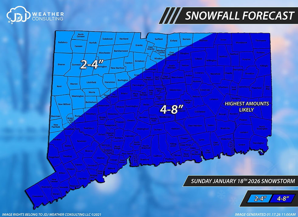
The forecast remains mostly unchanged, though we shaved back the upper end of the 4-8" range. Expect most areas to pick up 4-6" with lesser amounts in the NW corner of the state. There may be some localized areas above 6" in the heavier banding, up to 8". The greatest threat for this is along the shoreline and Eastern Connecticut.
Snowfall Forecast:

Current Radar:
Previous Post:
If you have been following our updates, you are aware of the dynamic developments in snow forecasting this week.
The snow event on Saturday shifted southward this morning, resulting in 1-3 inches of snow across a significant portion of Connecticut, with 3-8 inches recorded in the Northern Hills. As of late last night, it was generally believed that most of the snow would be limited to Northern Litchfield County and areas northward into the Berkshires. However, the snow band ultimately moved approximately 50-75 miles further southeast than initially predicted.
Regarding the Sunday storm...
We have been monitoring a potential snowstorm this weekend. The prevailing weather pattern has posed significant challenges for our computer models. This period was identified as having potential for a snowstorm several weeks ago, and our models began to reveal this possibility on Wednesday. However, only the American model and our AI weather models consistently indicated accumulating snow over Connecticut. As of Friday morning, our two leading models, the GFS and EURO, did not predict snow over Connecticut. Nevertheless, late on Friday night, all of our typically reliable models began to align with the AI models, forecasting a snowstorm. As of today, there is strong consensus on a widespread snowfall of 4-6" locally up to 8 inches across the state.
Forecast:
Snow is expected to develop between 4-7AM across the state on Sunday morning, the snow will accumulate 1-3" by midday.
We anticipate a reduction in snow intensity around midday as the storm intensifies to the south. Roads are expected to remain mostly wet during this period.
Snow intensity is expected to increase again after 3 PM, with an additional 2-4"+ likely through Sunday night.
The snow is expected to taper off after midnight on Sunday night. Most snow totals will be in the 4-6" range , however any areas that sit under a heavier snow band may see up to 8". We will continue to refine this forecast as necessary and aim to identify where heavier snow bands may develop. Thank you for your patience and support. - JDJ


Comments