
Record Cold and Potentially Stormy Pattern Settling in.
- JDJweather
- Jan 19
- 3 min read
CT residents are waking to a breathtaking Winter Wonderland this Monday morning. Over the weekend, four waves of precipitation dropped a total of 5-10 inches of snow on the region. The snow, being wet and undisturbed by wind, has left every branch and tree perfectly coated in white.
Unfortunately for those that don't enjoy snow and cold, we have a few intense waves of Arctic air set to move into the North East over the next 15 days, with the first arriving tonight. We are also closely monitoring what could be a snowy 2-3 weeks as we head into February, the first snow threat will be this weekend with another possible as we close January.
Let's dig in..
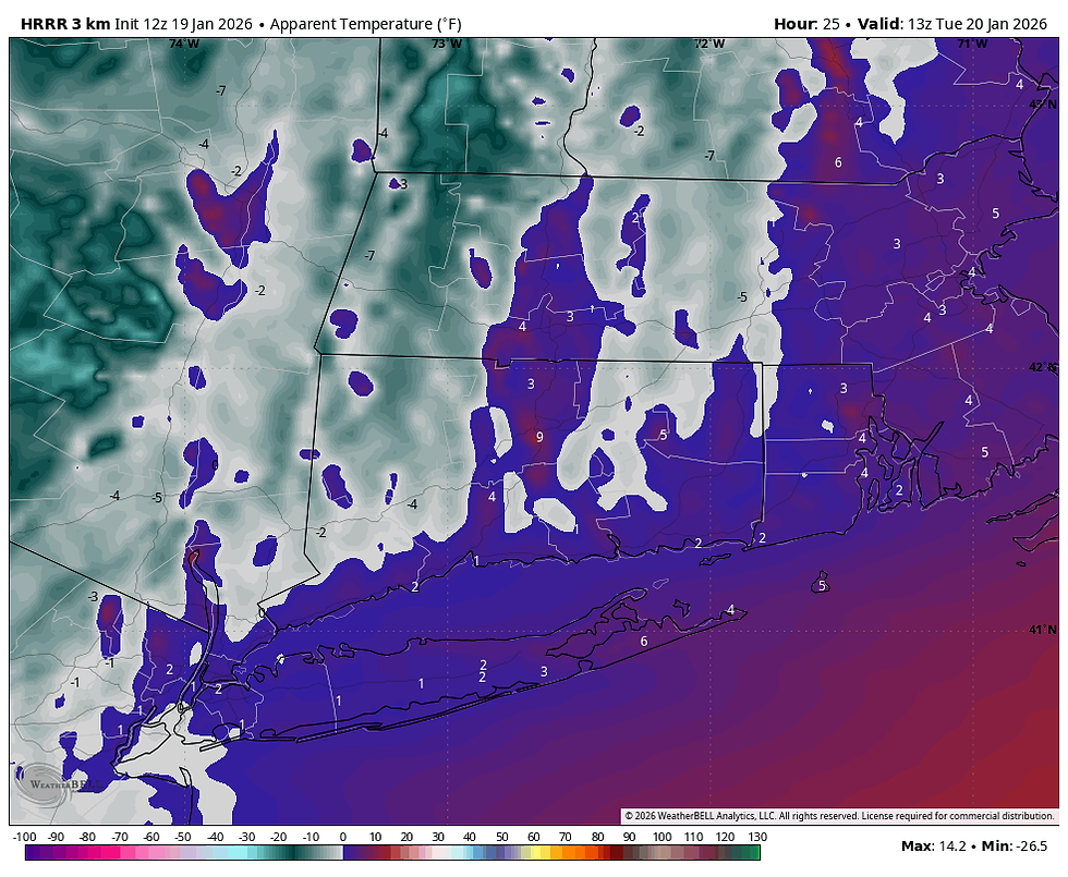
Bitter Cold Monday night and Tuesday
It's already pretty darn cold today, with high temps forecast to range from 25-32 across the state, however a reinforcing shot of arctic air will move in later this evening. Temperatures will drop quickly into the single digits and teens with wind chills between 0 and 10 below zero. Temperatures will struggle through the teens on Tuesday with wind chills around zero all day. Here's a look at bus stop wind chills for Tuesday morning.
Severe Cold Coming This Weekend
Temperatures will moderate to seasonal levels Wednesday through Friday before what could be the most intense arctic outbreak we've seen in a decade moves in Friday night through next week. This map is a 5 day temperature anomaly over the Eastern US. It shows temperatures 20-25 degrees below normal over a five day period, this would imply high temperatures in the teens with lows well below zero for five consecutive days. If this verifies, there's no doubt a few records would be broken. Temperatures should moderate back to average for early February, however early indications are February could feature more arctic cold shots.

In terms of snow, we are watching two distinct periods this weekend and Jan 28th through 30th for significant snowstorms.
Jan 24-25th Snow threat
When meteorologists look at the pattern beyond a few days we like to use the 500mb charts, this is the flow of "energy" at 18,000 feet. This gives us a clearer view of the pieces of energy at play. When we look at the 500mb chart for this weekend and beyond we see similarities to some major New England snowstorms. The first threat is this weekend, which looks a lot like Feb 16-17 2003. Here is the link below on that storm summary (we are not forecasting a repeat of that storm as of Monday morning).
Before we "freak out" or celebrate if you like snow ... it's not as easy as making comparisons to past patterns, it never is. Just because the 500mb chart is similar to past major storms, it doesn't mean that the computer models agree on the placement of other important ingredients for a storm. As discussed above a major shot of arctic air is set to arrive Friday night, the question is, does this cold dome push our approaching snowstorm south and leave us cold and dry, or does the arctic energy merge with the approaching storm and produce a major snowfall for our region? Time will tell.. As of Monday morning the AI models like the idea of bringing the snowstorm into our region, while the traditional weather models keep it down south for a Mid-Atlantic snowstorm. We are still new to the use of AI weather models and they cannot be 100% relied on, however the AI computer models were the first to catch on to the idea of our weekend snowstorm. Right now a corridor from Richmond Virginia to Baltimore Maryland is favored for heavy snow, however history does tell us, snowstorms coming from the south with gulf moisture tend to come north last minute.

Jan 28th - 30th Stormy Pattern
As the cold air starts to moderate with the right features in place at 500mb we usually open up windows for an important snowstorm. This looks to be the case this year too. A classic snowstorm setup looks to be in place for the Jan 28th-30th period. We have many key features in place for a big one.
Ridge in the west over Idaho (orange colors)
Decaying -NAO ridge over Canada (red over Hudson Bay)
50/50 low (green on the upper right corner of map)
Trough over the Eastern US (blue and greens)
This period is still about 9-11 days away, we will closely monitor as our computer models have been showing this potential for several days now. Stay tuned active times ahead - JDJ


Comments